
Rooted in Renewal.
A Regenerative Living Community
PROJECT 17 / 17
7 PRESENTATION SHEETS
A community where homes, shared growing spaces, and composting form a continuous cycle of living, production, and renewal. An opening third-year exploration of housing, landscape, and collective care.
Architectural summary
This community study connects housing with shared growing, cooking, dining, and outdoor movement. Research graphics and precedents introduce the project, followed by housing plans, sections, and site diagrams that organize repeated residential clusters within a connected landscape. Atmospheric collages explore planted thresholds, covered paths, and places where residents can gather around everyday activities.
Concept & Program
STUDIO V / SHEET 01Homes, edible landscapes, community gardens, and shared courtyards connect everyday living with food cultivation. Composting returns kitchen and garden waste to the soil, making the cycle of consumption, decomposition, and growth visible. The proposed programs include cooking and gardening classes, shared dining, a farm-to-table café, food education, a greenhouse, and a produce market.
Food and Compost Research Graphic
A research graphic groups diet, composting, and food-waste figures into charts, introducing the social and resource questions behind the community proposal.
Community Health Research Graphic
A research chart compares reported health categories across geographic areas, providing background context for the proposal’s links between housing, food, and activity.
Growing to Movement Program Sequence
A program diagram links growing, learning, cooking, eating, and movement, associating each activity with a shared space or route in the community.
Original sheet & annotations +
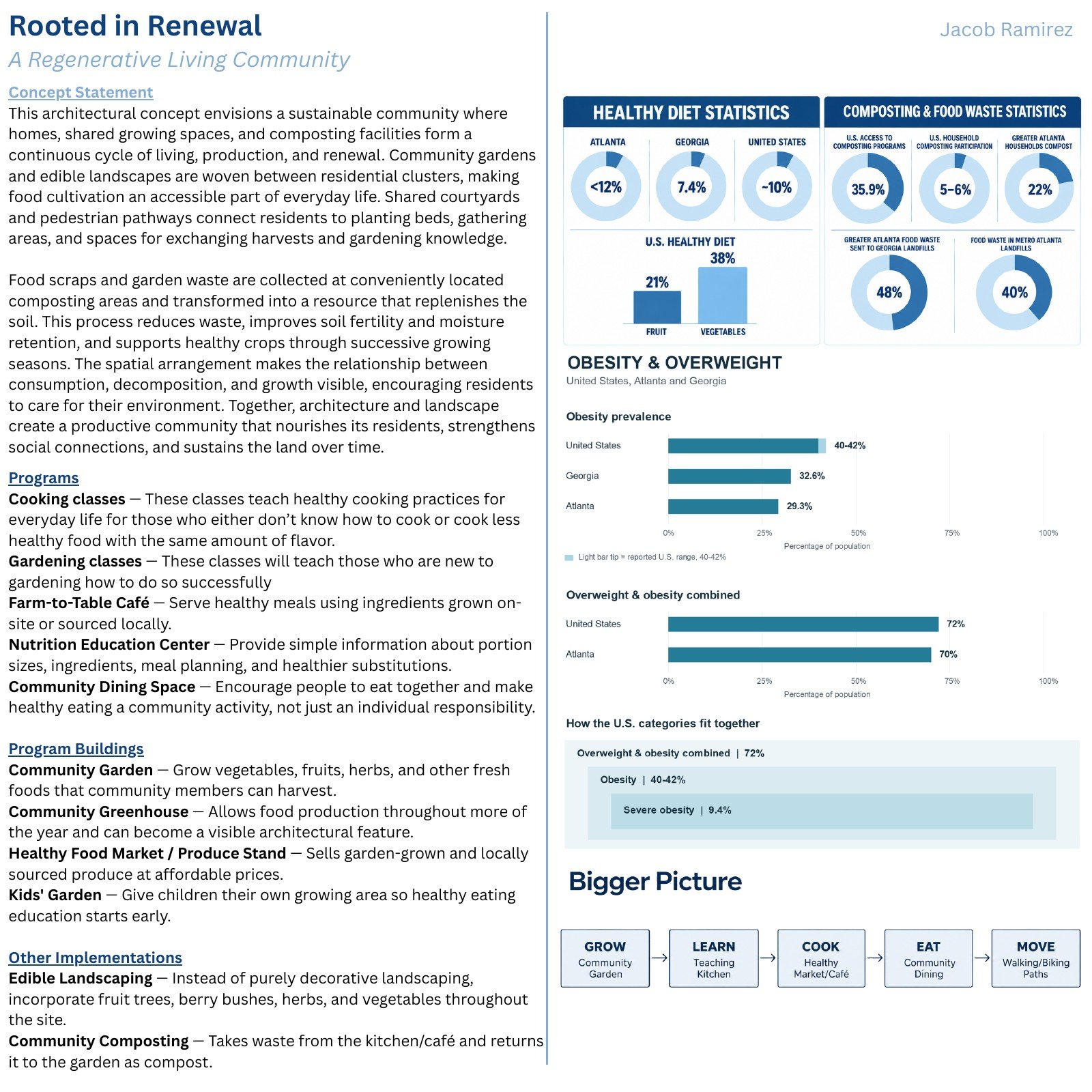
Rooted in Renewal: concept & program. This presentation sheet brings together food and compost research graphic, community health research graphic, growing to movement program sequence, preserving the original layout and annotations.
Site diagrams
STUDIO V / SITE ANALYSISA study of built form, landscape, movement, and environmental conditions. Open any diagram to explore its details.
Download original diagrams PDF ↗Building Height Diagram
This map uses different blue tones to distinguish buildings across the surrounding street network, introducing the neighborhood height study through its pattern of individual footprints.
Floor Area Diagram
Filled building footprints show the distribution of built area within each block, contrasting tightly spaced smaller buildings with larger footprints near the edge of the study.
Building Floor Diagram
This diagram outlines the surrounding building footprints and highlights selected buildings in pale blue, keeping the street pattern visible for comparison with the other building studies.
Slope Diagram
Green and yellow shading overlays the surrounding blocks in this slope study, showing how the mapped terrain pattern relates to streets and building footprints.
Vegetation Diagram
Green circles mark vegetation across the neighborhood, showing concentrations along streets and within blocks while leaving the underlying circulation network visible.
Contour Lines Diagram
Contour lines run beneath the building and street pattern, describing the terrain surface and its relationship to the surrounding built fabric.
Sun Diagram
Curved sun-path lines and a shaded arc overlay the neighborhood plan, relating solar orientation to the surrounding street grid and building pattern.
Close-up Sun Path Diagram
A three-dimensional neighborhood model sits beneath an arcing sun-path dome, showing the modeled solar trajectory in relation to the arrangement and height of surrounding buildings.
Traffic Heat Map Diagram
Warm shading follows the street network over the building plan, presenting the traffic heat-map study as a comparison between routes and the surrounding urban blocks.
Population Diagram
Translucent purple areas highlight parts of the neighborhood in this population study, allowing their distribution to be read against existing buildings and streets.
Street and Road Diagram
The street diagram removes building detail to isolate the network, showing straight routes, curved residential loops, junctions, and smaller branches within the study area.
Traffic Slowdown Diagram
Colored lines trace selected streets in the traffic slowdown study, relating changes along the routes to intersections, curved streets, and the surrounding building pattern.
Layered Site Analysis
An exploded diagram separates nine labeled site layers, including building use, vegetation, traffic, contours, sun path, and shadow, allowing their spatial relationships to be compared.
Close-up Stacked Diagram
This stacked analysis separates slope, transport, and building information above a combined base map, showing how natural and built patterns align across the same area.
South-to-North Section Diagram
This landscape section follows an undulating ground line beneath overlapping tree canopies, showing the relationship between vegetation and terrain along the south-to-north direction.
West-to-East Section Diagram
The west-to-east section shows tree canopies over a ground profile that dips toward the center and rises toward the right, describing the site’s changing terrain.
Precedent: Habitat 67
STUDIO V / SHEET 02Architectural precedent: Habitat 67 by Safdie Architects. Reference imagery and analytical diagrams are presented as part of the research for Rooted in Renewal.
Habitat 67 Precedent Photograph
A precedent photograph shows Habitat 67’s stacked residential blocks, where projecting volumes, planted terraces, and openings create a varied silhouette above the landscape.
Housing Blocks and Shared Paths
An analytical massing illustration arranges blue housing blocks beside shared paths and planted areas, making the relationships between individual units and open space visible.
Terraces Between Offset Units
This close massing illustration shows offset residential volumes with planted terrace edges, emphasizing the spaces created between adjacent blocks at different positions.
Stacked Housing from Below
An analytical axonometric illustration views the housing cluster from below, exposing overlapping volumes and recessed terrace spaces within the arrangement of blocks.
Highlighted Modules in the Precedent
A photograph of Habitat 67 carries blue overlays on selected blocks, drawing attention to the repeated residential units within the larger stacked composition.
Precedent Massing Along the Approach
A precedent photograph with blue overlays traces selected volumes above a stepped pedestrian approach, showing how projecting units shape the space below.
Original sheet & annotations +
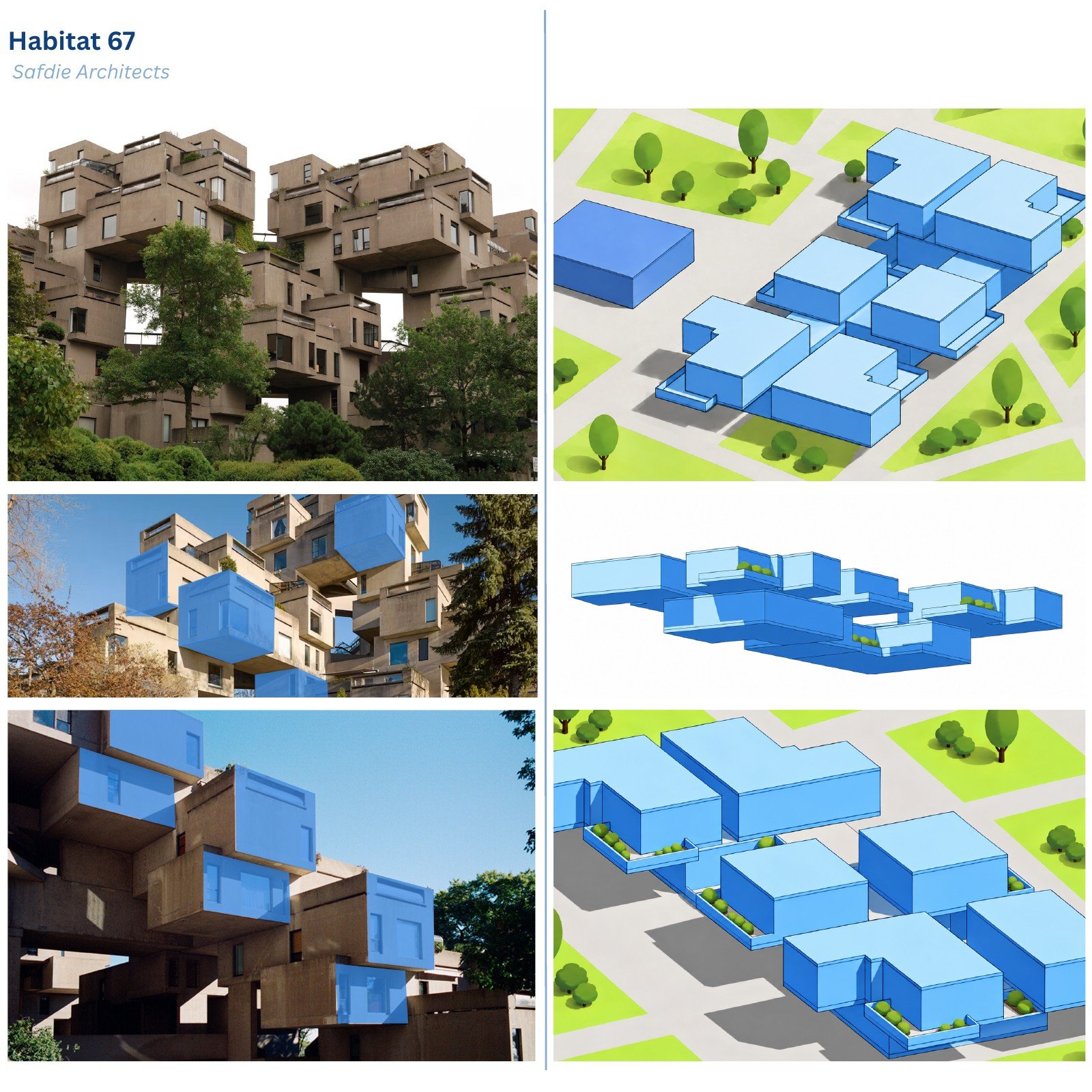
Rooted in Renewal: precedent: habitat 67. This presentation sheet brings together habitat 67 precedent photograph, housing blocks and shared paths, terraces between offset units and related views, preserving the original layout and annotations.
Precedent: Senior Cohousing
STUDIO V / SHEET 03Architectural precedent: the senior cohousing study attributed to Vandkunsten Architects in the original presentation. Reference imagery and analytical diagrams explore clustered homes, landscape, and shared spaces.
Cohousing Clusters from Above
An aerial precedent photograph shows low residential clusters arranged around small shared spaces, with paths connecting the settlement to the surrounding open landscape.
Greenhouse Beside a Shared Terrace
A precedent photograph shows a glazed growing space beside a paved terrace, with outdoor furniture and planting connecting the building edge to open fields.
Shared Path Between Homes
A precedent photograph follows a broad path between low houses, where front gardens and outdoor seating open directly onto a common landscape.
Paired Units and Planted Edges
A massing illustration groups blue residential volumes around shared routes, with small planted terraces marking the edges between individual units and open space.
Precedent Clusters on the Site
An annotated precedent plan uses three blue overlays to identify housing groupings within a larger landscape of paths, trees, and shared open spaces.
Original sheet & annotations +
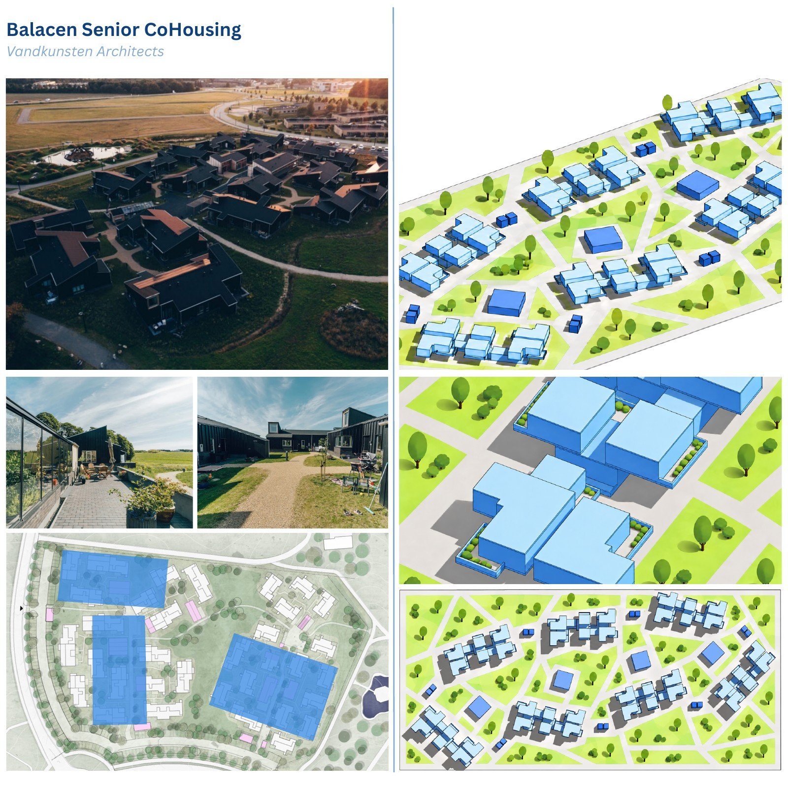
Rooted in Renewal: precedent: senior cohousing. This presentation sheet brings together cohousing clusters from above, greenhouse beside a shared terrace, shared path between homes and related views, preserving the original layout and annotations.
Units & Shared Spaces
STUDIO V / SHEET 04One-, two-, and three-bedroom housing studies, with elevations, sections, and relationship diagrams. The arrangements connect private rooms with shared living and patio or garden space.
Three Housing Plan Variations
Three furnished plan diagrams compare compact and larger housing layouts, showing how bedrooms, bathrooms, and shared living areas fit within different footprints.
Stepped Housing Elevation Study
An elevation diagram combines low and raised housing volumes, with terraces, windows, and trees describing the changing rhythm along the residential edge.
Upper Volume Above a Smaller Base
A simplified section diagram places a long upper volume above a narrower lower level, highlighting the projection and the space left beneath it.
Alternating Open and Enclosed Volumes
A long sectional illustration cuts through a series of housing blocks, revealing interior floors and openings alongside terraces and connecting lower volumes.
Rooms Across Two Stacked Levels
A sectional illustration shows rooms and openings across two offset floors, with the upper level extending beyond the footprint of the lower volume.
Original sheet & annotations +
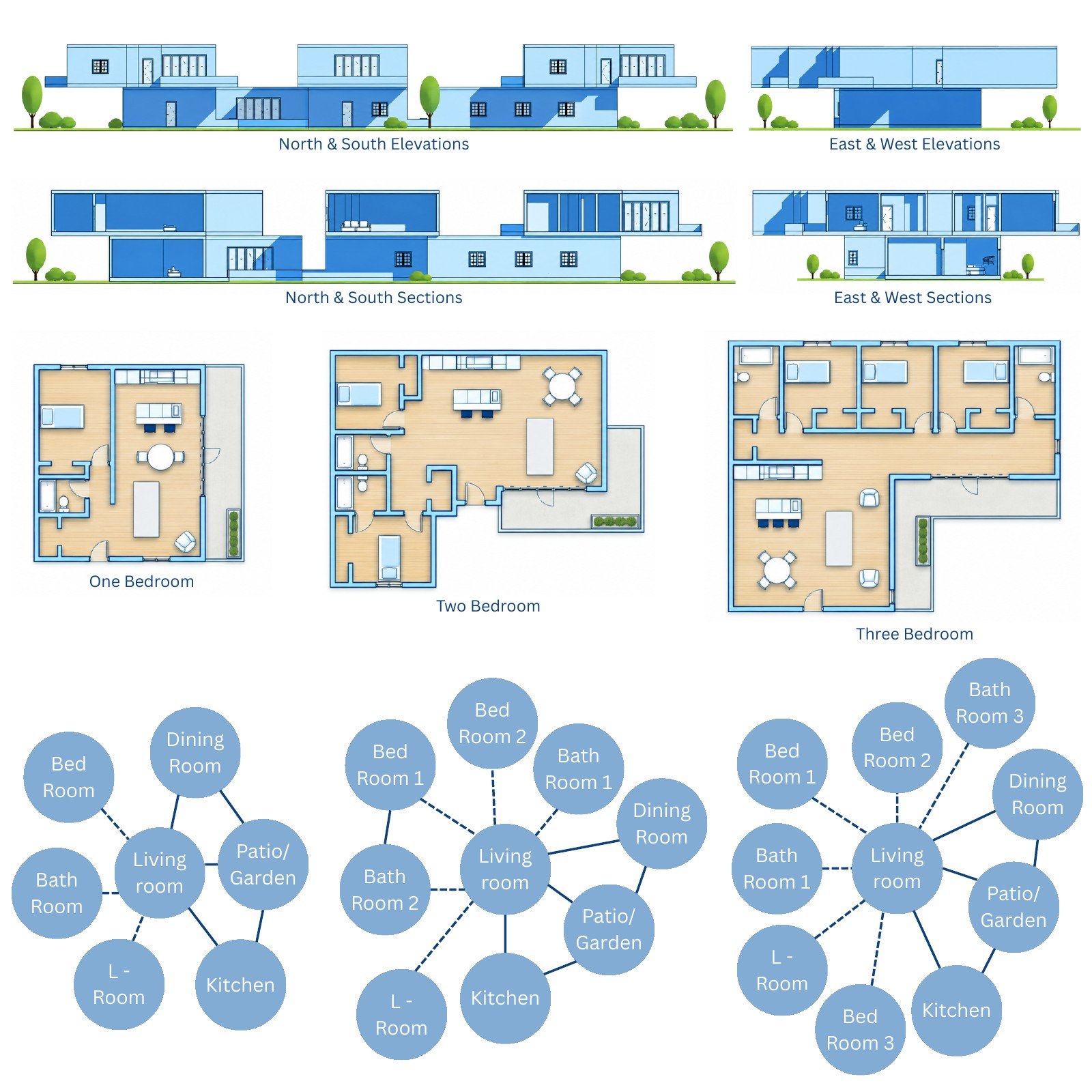
Rooted in Renewal: units & shared spaces. This presentation sheet brings together three housing plan variations, stepped housing elevation study, upper volume above a smaller base and related views, preserving the original layout and annotations.
Site & Community Clusters
STUDIO V / SHEET 05Housing clusters, community gardens, shared dining and cooking spaces, and composting stations create an interconnected landscape. The diagrams explore how these programs support a cycle of living, growing, and renewal.
Community Clusters in Plan
A site plan distributes repeated housing clusters among planted open spaces, shared paths, and freestanding communal buildings, showing the organization of the whole proposal.
Community Landscape in Axonometric
An oblique site illustration shows the housing clusters as a connected landscape, with paths weaving between repeated building groups, trees, and smaller shared structures.
Original sheet & annotations +
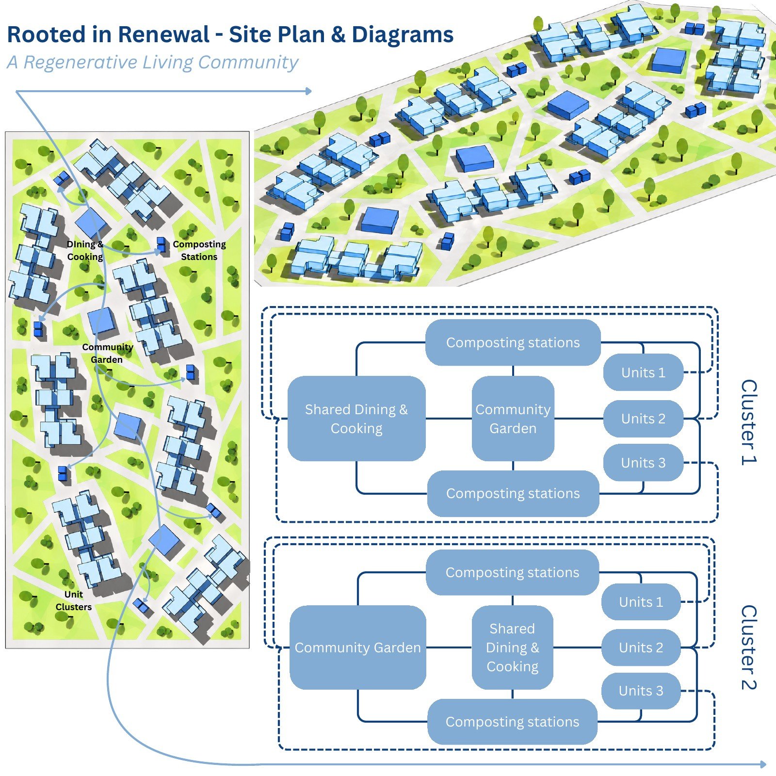
Rooted in Renewal: site & community clusters. This presentation sheet brings together community clusters in plan, community landscape in axonometric, preserving the original layout and annotations.
Community Collage
STUDIO V / SHEET 06An atmospheric collage exploring communal growing, gathering, and the experience of a productive landscape.
Growing and Gathering Collage
An atmospheric collage combines planted beds, a glazed enclosure, and communal tables beneath an open canopy, bringing everyday growing and gathering into one scene.
Original sheet & annotations +
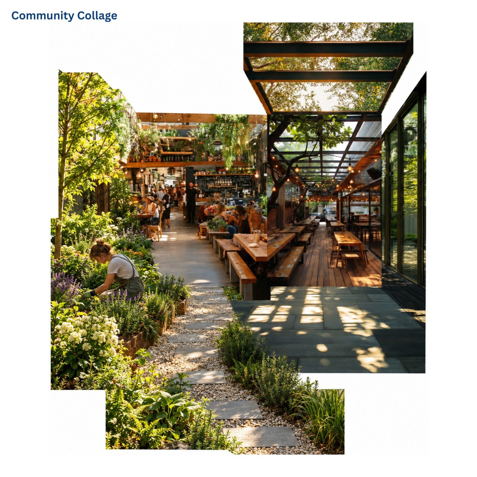
Rooted in Renewal: community collage. This presentation sheet brings together growing and gathering collage, preserving the original layout and annotations.
Architectural Collage
STUDIO V / SHEET 07An early collage study of planted thresholds, shaded circulation, timber forms, and the relationship between architecture and landscape.
Planted Thresholds and Covered Walkways
An architectural collage combines a planted pergola, garden paths, and projecting building volumes, exploring the transition from landscape through sheltered circulation to enclosed space.
Original sheet & annotations +
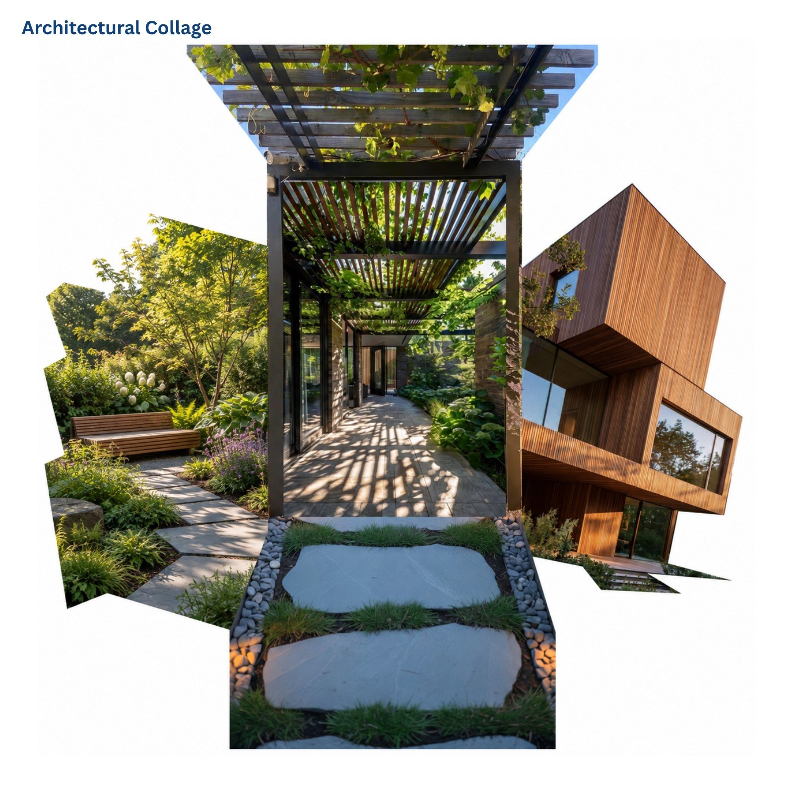
Rooted in Renewal: architectural collage. This presentation sheet brings together planted thresholds and covered walkways, preserving the original layout and annotations.